I Want The City, But I Want The Country Too
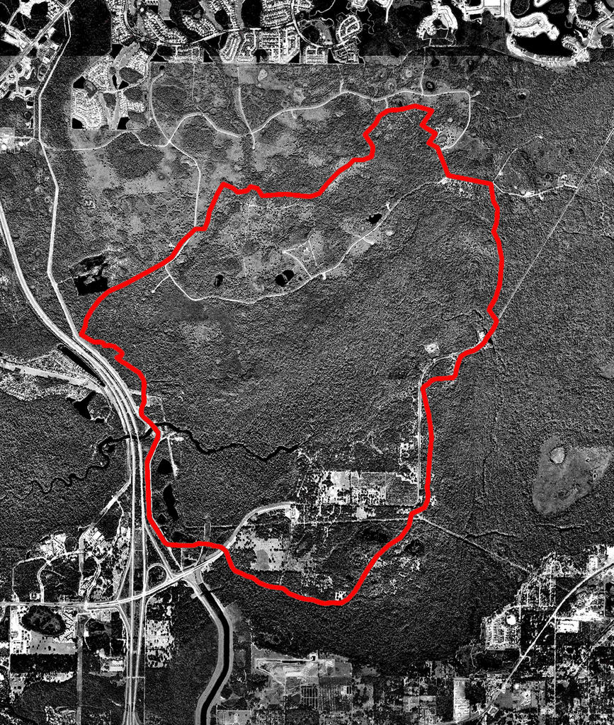 Wilderness Loop 15mi
Of course there are requirements to be satisfied. So many miles on certain days. Areas of historical significance. Routes from home. Routes from work. And there are rules to follow.
Always run east first. In the morning the rising sun will light your way and the trees will keep it out of your eyes. As the sun gets higher and hotter, you will turn your back to it and run home. In the evening it will guide you home as it sinks below the western horizon.
I study the narrative to be recalled on the next day’s run. Here are the mile markers. Here are the names of unfamiliar streets. Here is a water fountain. A bathroom. The river.
Today’s run involved more reconnaissance than usual. I knew there was a trail connecting the Wilderness Parks of the northern Hillsborough, but I had no maps and no information on it. I’ve been reading a history of the river by Gloria Jahoda entitled “River of the Golden Ibis”. Her descriptions of this area in the days of Ponce De Leon and Hernando De Soto have pushed me to explore these northern sections of the river basin, which remain, in places, similar to the way the conquistadors found them almost five hundred years ago. I drove from park to park until finally at Flatwoods I found a photocopied flyer of the route with no scale or mile markers. The flyer said that the total length of the trail is 15 miles, but I later found some information online that showed the length to be anywhere between 17 and 20 miles. After having run the route I feel confidant that it is very close to 15 miles. A long 15 miles.
The second version of the days run is written on the trail. It is typically just a litany of complaints, punctuated by brief moments of discovery and even fear. The morning starts with a string of obstacles: oversleeping, disorganization, stomach troubles, and a dead battery in the van. By 8:00 am though I am at the trailhead, slathered in sunscreen and looking sporty in a new running outfit.
I start out running south from the Trout Creek Site along the raised levee road. The road is a good twenty feet above the surrounding landscape, but the tall pines on either side still provide a bit of shade in the low-angle morning light. After the first exposed mile, the trail ducks into the underbrush of palmettos and scrub oaks. A sandhill crane stands at the trail’s entrance to the woods, undisturbed by my passing.
The area to the east of Morris Bridge Road is a maze of trails and loops popular with mountain bikers, but the main trail is well marked and on this early weekday morning I have yet to see another human. The bugs have found me though. Twice I swat the sunglasses off of my head as I try to defend myself against the horseflies on my face.
As the trail turns north and heads back towards the river, it opens up and straightens out a bit. Either the bugs have subsided or I’ve started blocking them out.
At Morris Bridge Park, the trail parallels the road briefly, and I spot an enormous alligator sunning itself in the duckweed gathered at the base of the bridge. A mile further, bright bands of color move lazily across the trail in front of me, and I struggle to find a grade-school mnemonic in a memory bank now deprived of oxygen. “Red touch yellow kills a fellow.” Coral snake. That’s enough to bring me back to reality, and I scan the trail ahead intently. At a distance every root, tree branch, and vine becomes a coiled rattlesnake waiting to strike. A startled armadillo explodes from the dry leaves at the base of a nearby palmetto, and I decide that it’s time for a quick pee break because I’ve almost wet myself.
Around the two-hour mark, I realize that I’m running in a kind of fog. My head is just floating along, dragging my body and legs behind it like a jellyfish. The breeze is starting to give me a chill and it must be at least 85 degrees by now. I suck down one of the gel packs that I’ve brought, along with part of a Clif Bar. This perks me up a little bit, but as I wash down the sickening-sweet-cake-frosting taste of the gel pack, I take a hard pull on my drinking tube and realize that I’m out of water. This is when I start composing the opening lines for Version Two. “Everyone has a bad run sooner or later and today was just my turn…”
I’m well past the last water stop and there’s no way that I’m turning around. I slow my pace and increase the frequency of my walk breaks and soon I’m not feeling too bad. The last half hour consists of more walking than running and I still manage to finish in 2:57:00. I must have gone out way too fast, but the lack of accurate mile markers has made it hard to judge.
Back at the park I shower off, change clothes, and drink two of the best tasting sodas I’ve ever had. Hooray for 82 grams of sugar.
On the drive home, forces beyond my control bring the van to a stop in the mall parking lot where I hastily consume a large bacon cheeseburger at a brass-n-glass establishment. I sit reading “River of the Golden Ibis” while the waitress repeatedly refills my drink, and the final version of the day’s events starts to take shape. It takes a certain amount of time and distance to forget the agony of a fifteen-mile run, but as the mind and body start to replenish themselves the connections develop and I can see the banks of the river populated by the huts of Timucua and Calusa Indians long before the Seminoles came to this area. I imagine Ponce De Leon and De Soto dragging their murderous and ill-equipped vassals through the same hummocks and thickets that I’ve just emerged from. I can see them mired in the Green Swamp, headwaters of the Hillsborough, weighted down by their ridiculous armor, trying to float rafts of pigs through the dense undergrowth of the swamp. My brief loss of clarity pales in comparison as I imagine the Indians who led them to their eventual deaths, moving them ever north with the promise that the riches they sought were always just around the next bend in the river.
posted by Livework Studios LLC at #
![]()
![]()
4 Comments:
This is one of my favorites. But I don't know what a gel pack is ... ???
oh, and can we see a picture of you in that new jogging outfit?
Thanks,
A gel pack is an electrolyte solution used by distance athletes. It is a little pack of goo loaded with sugar and other carbs. I'm sure you'll see the new outfit soon enough. I have been taking pictures with a little disposable camera, and I'm currently working on finding a smooth way to integrate them into the blog. They should be up in the next week or so.
i enjoyed your telling of one of my most favorite training routes. i was actually trying to track down the mile markers for this route.
Post a Comment
<< Home