Castles Made Of Sand
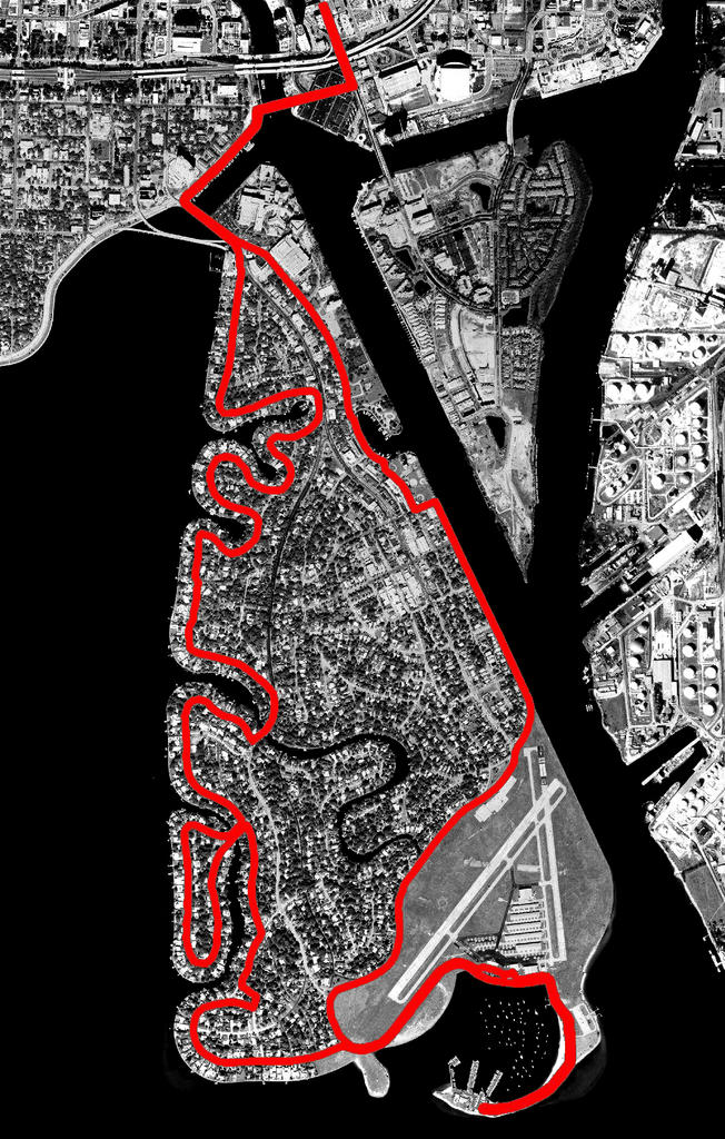
Davis Island 11mi
View Interactive Map
I got a bit lazy with my route planning, but I remembered that I had a preprinted map of an 11-mile route on Davis Island that I had picked up at the downtown YMCA. This route is like a fractal variation of last week’s run, eliminating the final stretch downtown, and following the coast in greater detail to achieve the additional mileage.
Parking the van in a spot near the Y, I realize that I only have enough quarters to put two hours on the meter. Luckily, I know the mileposts by now and I can gauge my splits pretty well, but I’ll have to run a record long run pace to be back in time. The threat of a $25 ticket waiting for me when I get back proves to be a great motivator.
I run the route clockwise this time and I’m off of the exposed sections on the eastern shore before the sun gets high enough overhead to be a real nuisance. Along the coast, it seems that this entire island is under construction. This is a perfect place for a runner with stomach problems as there is a Port-O-Let every 200 yards. Today I’m in too much of a hurry to make use of them, but last week I was glad they were there.
I’m thinking about New Orleans and the change of perspective caused by rising floodwaters. My image of this island is shaped more by aerial photos than by street level views. I look at the blue-glazed ceramic tile roofs and wonder if I could pick them out on the aerial photos. The majority of people in New Orleans had an image of their city that was shaped by their mostly street level, pedestrian experience. Now their city is a series of rooftops in the Gulf of Mexico. I read that many of the first responders from other parts of the country were having difficulty finding their way around this unfamiliar city, but I would bet that many long-term residents had trouble adjusting to the sudden shift in their vantage point. What would our cities look like viewed in horizontal cross sections of 4, 6, or 10 feet of elevation? When we were hiking in Washington State, Jan and I crossed through several old avalanche zones where all of the trees had been broken off at the same height, now thirty feet above our heads. I remember standing on the trail in the ninety-degree heat, trying to imagine being in the same place at a different time, a snowfield littered with downed trees, oblivious to what lay beneath my feet.
Davis Island is a man-made dredge mound that sits in the delta of the Hillsborough River where it empties into Hillsborough Bay. If the river is our Mississippi, then this is our New Orleans, without the music, food, history, or culture. In contrast to New Orleans, here the wealthiest residents live along the coast in the island’s most flood-prone regions, perfectly poised to absorb any storm surge pushed ahead of an advancing hurricane and magnified by the constriction of the bay at this point. These people have cars though, lots of them, and they can navigate freely through the x and y of these maps we have formed, but it is only their yachts in the marina that will navigate the vertical axis of the rising tide. They will hold their positions long after the stinger-like tail of the island’s southern tip has disappeared beneath the waves.
I’m into the last mile and it looks like I can make it back in time if I don’t take any more walk breaks. Climbing the slight rise of the Platt Street Bridge, I tell myself to remember this pain. My lungs are burning and my legs are like sand bags, but I know that I’ll forget as soon as I can catch my breath. I dig in for the last quarter-mile, and my breathing is truly labored for the first time today. I cross Franklin Street at Brorein and make it to the van just in time to see the meter start flashing, “Expired”.
posted by Livework Studios LLC at #
![]()
![]()
0 Comments:
Post a Comment
<< Home