Wednesday, August 31, 2005

Just For The Halibut

Anchorage 10mi
I took an unscheduled trip to Anchorage, Alaska to act as a medical escort on a commercial flight for a patient being returned home from Anchorage to Madison, Wisconsin. We arrived around midnight Alaska time, and we didn’t have to pick up our patient until around 7:00 pm, so we had most of the day on Wednesday to explore Anchorage.
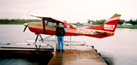
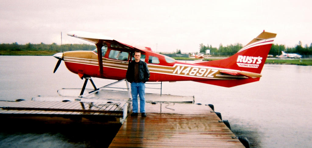
Our hotel sits on Lake Spenard, which functions as an airstrip for most of the floatplanes in Anchorage. We watch the planes coming and going as we eat breakfast in the hotel and we talk about taking a floatplane tour of the area. After breakfast we schedule a flight for 11:00 am, leaving just enough time for a quick soak in the hotel jacuzzi. Nine miles of running followed by twelve hours of flying has my legs feeling like two balloons full of walnuts.
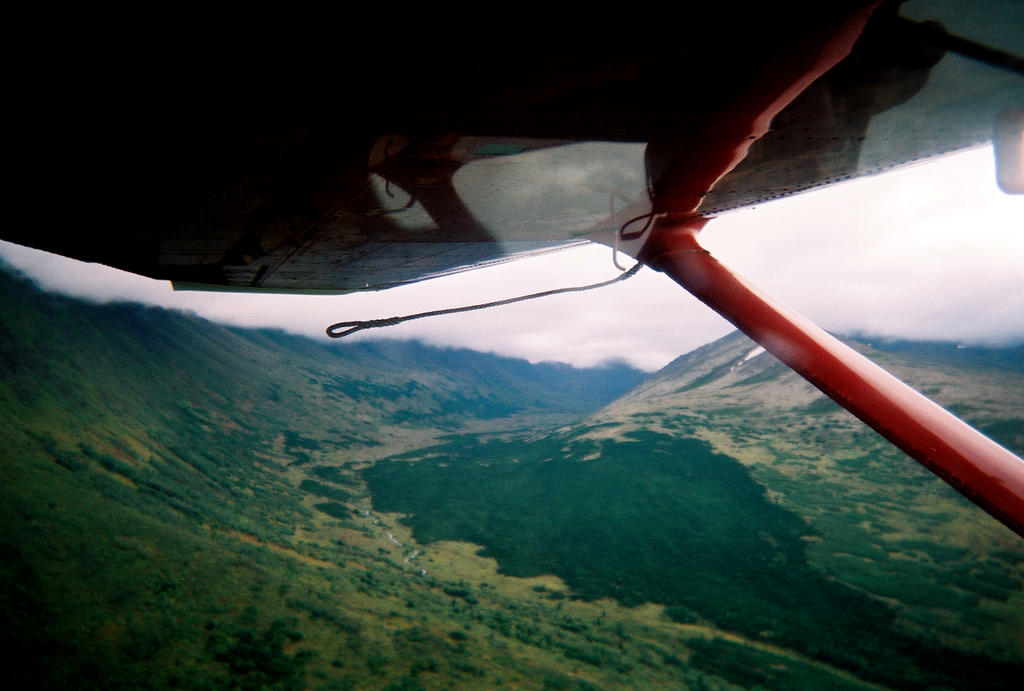
Soon we’re climbing into a tiny single engine Cessna for a short flight out of town and into the Chugach Mountains to the east. Somebody said that Anchorage is "only twenty minutes from Alaska", and now I see what they were talking about. As soon as we get over the mountains, civilization fades away and we watch Dall sheep grazing on the slopes between sparse patches of snow.
We’re ducking under the low ceiling of clouds (it’s been raining all morning), and the pilot threads the little plane through a narrow pass where the mountainsides seem to be just beyond our wingtips. Jayson asks our pilot Pete (a sort of twenty-something Tom Waits Of The Sky) if we are using VFR (Visual Flight Rules), which he confirms and then promptly f
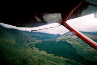
lies into a total whiteout. Exciting!
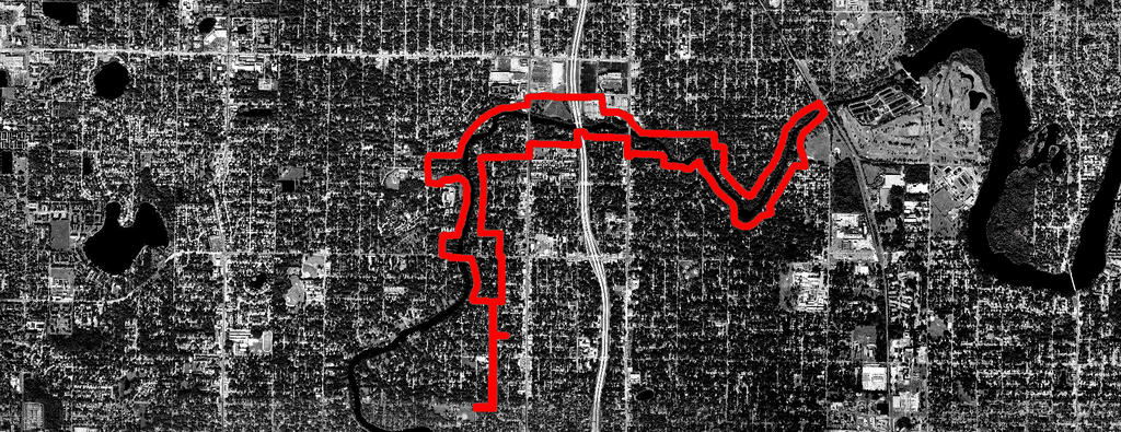
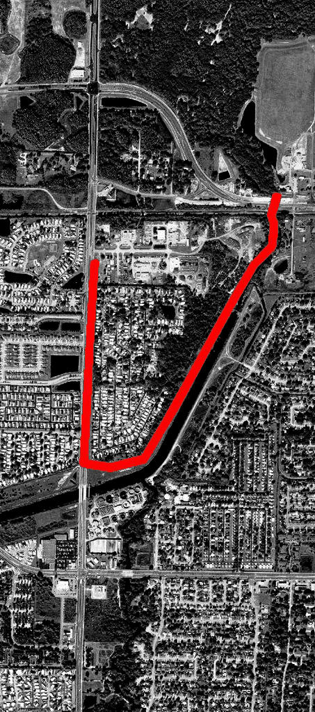
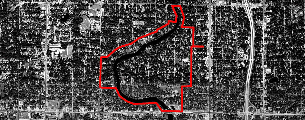
In the afternoon we make our way into downtown where we rent bicycles from another strange Alaskan named Pete. He insists that Jayson and I will not be comfortable in our jeans and leather shoes. He comes up with two pairs of his own shorts and shoes and presses them into our hands. He will not take no for an answer. We head out in our borrowed duds on two of Pete’s functional but slightly neglected fleet of rental bikes. Mine features a rear fender that Pete has hastily constructed out of duct tape to combat the rain-soaked streets, and Jayson’s bike is changing gear spontaneously, startling him and other passers-by. “Just don’t stand on the pedals,” I tell him and we head off 
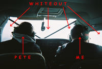
at a good clip along the Tony Knowles Coastal Trail.
It doesn’t take long for Jayson to figure out that I’m out for more than a relaxing bike ride, after all, today is my cross training day. Understandably, he would rather actually see some of the sights, and I let him go ahead and set the pace for the rest of the ride. We stop to read the signs about what to do when encountering a moose, and we stop in Earthquake Park to read about the devastation caused by the Good Friday earthquake of 1964. Just imagine a thirty-foot tidal wave covered in burning oil. You couldn’t make that up.


this is an audio post - click to play

Tuesday, August 30, 2005

It's The Little Things

Sulphur Springs 9mi
Today, for the first time, I repeated a long run route, simply adding a mile to the end of last week’s to make it the requisite 9 miles. I spent several hours the other day laying out a 9 mile route down the West Bank to Columbus and up through the Woodlawn Cemetery, but it was relatively exposed and the day was looking like it was going to be a scorcher. So I opted for the shade and the familiarity of the Sulphur Springs route as well as the asphalt and soft trails versus the sidewalks of my mapped route. The route that I mapped covers an area that I haven’t run before and I guess I feel somehow obligated to explore this side of the river. The route holds little appeal for me and I was prepared, I thought, to run it in the name of thoroughness and dedication to the cause, but now these seem like ridiculous notions. I have said before, and some of my recent readings have reinforced the notion, that the primary function of the writer or cartographer is not to compose, but to edit. To paraphrase Denis Wood, the only truly complete map is the world in front of us, and we already have that. However, in order to edit effectively, you must be familiar with those things that you choose to eliminate. And so I must run this route, but today is not the day.
I’ve been noticing lately a large number of toads smashed on the road. These toads seem to be of a variety that I am not familiar with, but they are large and extremely foul smelling when deceased. They all seem to have suffered the most violent of deaths, wherein their innards are expelled through their mouths in a lipstick-red tangle of heart/lung/intestinal tissue. I have been trying my damnedest not to slip on their carcasses as I run.
If last Tuesday I ran in the moment, reveling in the “discovery and wonder” of these new yet familiar environs, today I ran mostly in my head. I let the familiar streets pass beneath my feet, and I stayed inside myself, first feeling the tightness in my right shin and left achilles (it’s always here, despite running on the opposite side of the road, stretching, etc.), then the relief of the mulched trail through the Hobo Jungle.
I reach the railroad trestle and I’m back in the moment, concentrating on making the leap from tie to tie without slipping while listening for distant trains.
It’s these moments that last in my memories as the rest of the run fades away. This is the attention to detail that concerns Corlis Benefideo, and it is this attention that makes active pursuits fill our memories of the past. A week spent sunbathing in the Caribbean may be a great tonic for the usual stresses of work and home, but to traverse a snow field in the morning sun or to pick your way along a rocky ridge in a thick fog, these memories can be recalled minute by minute. Two years after the fact, I could write a paragraph about each one of the one hundred miles that Jan and I hiked on the Wonderland Trail.
This is not what today’s run is about. Today is one foot in front of the other. Step, step, step, breathe. Sweat. Drink. Repeat.
Except for that trestle. And the frogs.

Saturday, August 27, 2005

Bringing Up The Rear


North UTBT 3mi

Today I’ve recovered enough for a slow run on the UTBT before work. Another Saturday morning with packs of runners on the trail even before the sun has come up. Most of them are running a faster pace than me and I let them pass, avoiding the temptation to push any harder. About two miles in I’m passed by my old captain and we exchange greetings, but he’s running seven-minute miles so we don’t talk for long.

Friday, August 26, 2005

Forward March


Lowry/Boulevard 3mi

My legs hurt. Imagine that. Maybe someday I’ll learn to practice a bit of restraint.
I went for an easy walk with Jan through Lowry Park and I tried to work out some of the kinks. I pointed out the domain of the Squirrel Whistler and watched a Man Who Looked Like Kenny Rogers practicing ROTC honor guard maneuvers with a folded umbrella.

Thursday, August 25, 2005

Into The Light


West Bank 3.6 mi

Once again, my legs started to feel good and I wanted to go right out and do another speed session. I settled on the familiar West Bank route because I knew where the mile markers were, and I could have a point of comparison from previous runs.
I start out from the house and I can feel that my pace is a quick one, but I feel strong and it’s nice to stretch out a little. At my first walk break I’m more than a minute ahead of my normal pace, and the first mile comes in at 8:00 including the walk break. If I can maintain this pace for a 5k, I may be within striking distance of a four-hour marathon.
I’m running down the middle of the road, trying to concentrate on my form, and my focus is becoming more and more narrow. Soon I’m down to just the most essential: step, step, step, breathe. At about 2.5 miles I come up against the proverbial wall. I stop for a walk break and then shift into an easy jog. It’s as if a light comes on. My vision opens up, I hear the sound of the street, and I feel myself moving out of this tunnel of hypoxia. I keep the pace down for the last mile or so, and I still manage to cover the 3.6 miles in 32 minutes, a new personal record.

Tuesday, August 23, 2005

A Pathetic Fallacy

Sulphur Springs of Darkness 8mi

I had my doubts about being able to complete today’s run, but I eased into it and it turned out to be one of the best runs I’ve had to date. Eight miles is further than I’ve ever run before, so today marks the beginning of a journey into uncharted territory for me. I tried to focus my route as much as possible on the trails, sidewalks, and shortcuts that circumvent the mental roadmap that I have constructed of these neighborhoods along the river.
Jan commented on my previous post about the importance of “discovery” and “wonder” in this process, and it was these two feelings, exactly, that fueled me today. I wasn’t even bothered that I posted a personal worst pace of 12:42 min/mile, due, at least in part, to my having to run through ditches, weeds, mud, tall grass, and drainage culverts, as well as crossing a rickety bridge and a railroad trestle.
I start running slowly north on Ola, stopping to stretch the tightness in my calves at each five minute interval (in direct defiance of Jeff Galloway’s instructions), and I’m starting to loosen up as I take Hanlon east to the “troll bridge”, snapping pictures as I run through.
Following the Park Circle route, I head north at the dead end into the hobo jungle of Joel Brown’s Heart of Darkness. After a little bush whacking and ditch hopping, I find a nicely mulched road in the trees along the southern bank of the river. I’m keeping my eye out for the trail through the woods towards the railroad trestle, but the path is choked with weeds and I have to double back a few times before I find it. My shoes and socks are soaked from the tall grass and the morning dew, but soon the trail opens up again and I shoot some more pictures as I cross a little wooden bridge over a creek. Climbing up the embankment to the railroad tracks, I look cautiously in both directions before committing myself to the bridge. I’m skipping across the ties, watching the river flow beneath me, and reliving scenes of Stand By Me, when I realize the water has been replaced with the flow of morning commuters temporarily distracted by the crazy man up on the bridge.
At the foot of the trestle I stop to shoot some pictures of my favorite ill-proportioned manatee mural before heading into the beautiful Sulphur Springs Shopping District.
In describing present-day Sulphur Springs, “sleepy” is not generally a word that comes to mind, but it is surprisingly accurate at eight o’clock on a Tuesday morning. I run past the duplexes and 70’s split-level condos along the river, and I marvel at how little this area has changed in the years that I have known it. This is some of the only riverfront property in the area that has not seen a dramatic shift in demographics and property values in the last few years. The surrounding neighborhood of Sulphur Springs simply does not have the architectural “bones” of places like Seminole Heights and Tampa Heights. These streets look much the same as they did almost twenty-five years ago when I lived in a little house on the corner of Bird and Semmes with my mother and brother.
I cross Nebraska Ave. and pass the Sulphur Springs pool and gazebo, waving and saying hello to the homeless men sitting at the picnic tables by the river. I follow a path between two fences to the northern side of the “troll bridge” and find that, what looked like a trail from the aerials is actually a drainage culvert running along the interstate. I have to squeeze through a hole in the chain-link fence to follow the culvert north to the sidewalk on Bird Street. The stretch along Bird past the water tower is the first full sun that I’ve seen on this route, and I’m happy to cross Florida Ave. again, towards the shade of Lowry Park.
On the path in the park, I almost step on a squirrel that has parked himself in the middle of the right-of-way, and refuses to yield. Ahead I see an elderly man that I have encountered here on previous morning runs. He walks slowly along, whistling, and feeding the squirrels from a small plastic bag. “These guys really know who you are,” I say, commenting on the number of squirrels gathered around him. He tells me that they have even come to recognize his car and they gather around anxiously when he pulls up each morning. “They’re smarter than you think,” he says as I pass, and suddenly I’m a little offended. How does he know how smart I think they are? I’ve seen programs where squirrels learn to solve complex puzzles involving multiple feats of physical and mental dexterity, performed in an exact sequence, all for a small morsel of food. To me this says that they are at least as smart as children, who can’t even feed themselves without supervision, and they may be more astute than a few adults that I know or have met.
I continue down the trail, the old man’s whistling still in my ears, and I see squirrels from all over coming down from their trees and taking their places in the center of the path. They hold their ground and wait patiently as I pass.

Sunday, August 21, 2005

"His Dreams Walk About The City Where He Persists Incognito"


title excerpted from W.C. Williams' "Paterson"

North UTBT 3mi


I think that I needed the two days off to rest my legs a bit, and the weekend was pretty hectic anyhow. I’m thinking of swapping my Saturday and Sunday routines so that I run on Sunday. This makes it easier to crosstrain because the gym is always open on Saturday. I think a lot of other training programs have the day off following the long run, and I think this might be more to my liking as well.
Today I was back to work and my training schedule called for crosstraining, but I was feeling a little guilty about skipping the last few days and I felt like I should get some running in. I ran the UTBT three-mile out-and-back route at a nice 11:00 pace. My legs felt tight the whole way, but they never got truly painful.
Cardiovascularly, I am definitely improving, even if musculoskeletally I can’t keep up. My pace this morning felt very comfortable and my heart rate at the split was still only 140. I see more and more how the temperature affects my heart rate, and I would guess that for every degree increase in temperature, my heart rate increases by about two beats per minute. I’m working on developing a formula that shows improved efficiency through training. This would be a measure of heart rate as compared to running pace.
Today I read some of Denis Wood’s writing online, as well as a short story by Barry Lopez titled “The Mappist”. I was struck by the similarities between these real and fictional characters (Denis Wood and Corlis Benefideo), and I began thinking more about what it is that is driving this project of mine. I realize that I still don’t have a distinct focus. I see more and more that my runs function more as reconnaissance than as research. For me to form a truly detailed and comprehensive map, I must read the histories of this city in its books, as well as in its streets and in the mouths and imaginations of its people. As Lopez writes in “The Mappist”, Benefideo’s book is based on the idea that the city is “the living idea of its inhabitants”.
InIra Glass’s interview with Denis Wood he says that Wood’s maps “make the neighborhood seem like a living organism”, to which Wood responds, “It is a living organism!”
Carlo said to me “your aerial maps look like pictures of Hiroshima,” and I saw the brutality in these images. It was not my intent to lay this city to waste. Today I’m thinking of softer representations of this city. I’m imagining a 3-D model on the brick floor of Flight 19 made of Cuban coffee and tobacco leaves. I’m thinking of hand-drawn maps on rag paper, I’m thinking about water; where it moves, collects, rises and falls. And I’m wondering why every city calls itself the “Lightning Capital of the World”.

Thursday, August 18, 2005

The Existential Cartographer

West Bank 3.6mi

My shins felt good and I wanted to run today. I decided to make a short loop of the west bank and run it fast without carrying anything. A 9:43 pace doesn’t seem too brisk, but I think this is the first time I’ve broken a 10:00 pace while using the walk breaks. My legs were a little heavy the whole way, but all in all I felt pretty good, and I was able to keep my heart rate under control. The lower temperature definitely helped.
The other day while working on the house I listened again to an episode of This American Life called “Mapping”. The segment in this show about cartographer Denis Wood provided much of the impetus for my ideas about this project. Wood wrote a book called “The Power Of Maps”, and he has produced an atlas of his Raleigh, North Carolina neighborhood that includes a map of the houses displaying jack-o’-lanterns on Halloween, as well as a map of the light pools cast by the street lights. Wood is interested in the way we form our images of a place through these types of personal and poetic maps.
When we were in college, Mike Baldwin gave me some of the best driving directions I’ve ever gotten. We were going to a party in Zephyrhills and I was going to drive out by myself after work.
Mike tells me to take Highway 301 north from Fowler Avenue and to “just keep driving until you think that you’ve gone too far.” This dark stretch of two-lane highway goes past Flint Creek and Hillsborough River State Park, and soon I’m shooting out through the palmettos and scrub oaks, paralleling the river’s lazy curves, straddling the line. “After a while you’ll start looking around in the dark. The moon will be out and you’ll be watching it through the trees. It’s so beautiful. Turn off your headlights and stick your head out the window. Look up. You’ll be watching the moon and the stars and you’ll have forgotten how far you’ve driven.” I‘m following his instructions exactly. It IS beautiful. I have my head out the window, first looking down at the asphalt screaming by beneath me, then up to the moon flickering behind the thin cypress branches. If I try to focus on the trees they are just a blur. I’m listening to the wind in my ears, the hum of the tires on the road, and the sound of crickets. I can’t remember how long I have been driving. “You’ll have forgotten how far you’ve driven. When you find yourself doing this – TAKE A RIGHT!” I slam on my breaks and look to the right as the small street sign blinks into view. I have arrived.

Tuesday, August 16, 2005

How To Get Lost In Your Hometown

Woodlawn 6.75mi

View Interactive Map

I was a little worried that this run wasn’t going to happen, but I managed to do it. I tried to get out the door a little earlier, but even at 8:00 its already too hot and running before the sun is up is a little precarious in this neighborhood. I don’t mind running out on the UTBT in the dark because there is no traffic, but here there are a lot of morning commuters that make me kind of nervous. I also have a tendency to run through some kind of sketchy areas, which is fine in the daylight, but I have this hang-up about wanting to see my attackers as they approach. I just hope that if I get chased it is in the first mile or two, when I still have a little kick left in me.
I didn’t want to aggravate my shins any further so I took things very slowly and just kind of shuffled my way along. I explored the route at the base of the MLK bridge and found that there is a footpath that goes underneath, eliminating the need for a street-level crossing.
I had planned my route to go through the Woodlawn cemetery, which is supposed to open at 8:00. As I approached from the south, just past Gram’s Place, the sign on the gate said to use the entrance off of Indiana. This is the gate that I had planned to exit from, and it would have added some distance to the route to go in that way. The route as I mapped it was 7.3 miles, and I figured if I just cut out the cemetery it would be closer to an even seven.
I brought a disposable camera with me and snapped a few pictures along the way. On the long runs, this is a nice way to slow things down as it gives you an unexpected break every now and then. Heading north on Ola I took some shots of the House of the Concrete Hand. The hand was probably six feet tall (not the ten feet I had remembered). My memory has a way of inflating my experiences. That’s what drives this project.
I try not to write about a run on the same day that I did it. I like to keep myself at least a day behind in my writing. This allows a little time for the process of forgetting, which is easily as important to good writing, I think, as remembering.
And so these maps are formed. Certain details fall away and others grow (17 percent becomes 60 and 6 feet becomes 10). There are places, I think, where my mind tends to wander as I run, and my physical experience of these places is almost non-existent. By doing something as simple as running the same route clockwise instead of counter-clockwise, the entire landscape is changed. This is something I have learned from backpacking: if you’re coming back the same way that you came, turn around periodically and have a look at your surroundings.

Sunday, August 14, 2005

Relapsing

The shin splint pain has returned a little, so I’m going to rest another day and hope that by Tuesday I’m ready to do a seven miler.

Saturday, August 13, 2005

Recovering

Carlo's 2.8mi

I felt a little better this morning and I ran to Carlo’s house to meet with him and Mike before going down to the Flight 19 space. The sun was a little intense, but I stuck to the shade wherever possible and I drank generously from the new Camelback.

Friday, August 12, 2005

Less Quick, More Dead

There are so many things wrong with my training from the last couple of days. My treadmill speed session was just the first misstep in this long chain of events. Yesterday I ran at least a mile further than I should have, and I did most of it on sidewalks (concrete being the worst possible running surface). Then there was my beer-as-carb-loading theory. Needless to say, today I don’t feel so hot. My waking pulse was considerably elevated, and I’ve been feeling the first signs of shin splints developing. I’ve dealt with this before and I know that I’d better take it easy or I won’t be running at all in a week or two. Today is going to be a wash

Thursday, August 11, 2005

The Quick And The Dead


New World 4.75mi

I think I’m feeling the effects of my little speed session yesterday.
One of my strategies to fit running into my day is to use the run as transportation. Joel called and said that he had finished his final exams and wanted to go out for a beer. I told him I would meet him at New World in Ybor in a couple of hours.
I had just gotten my Camelback hydration pack in the mail and I was anxious to try it out. I loaded up with water, ID, and cell phone and headed out.
While checking out the aerials for this route I realized that Ola Avenue runs due south from Seminole Heights to the end of Seventh Avenue by Tampa Armature Works. Ola is a small neighborhood street with good tree cover for most of the way.
For years, the section of Ola between MLK and Columbus has been on my Tampa tour itinerary for visitors who wanted to see the historic and eccentric side of Tampa. Running south on Ola below MLK there is a house on the west side of the road with a large (maybe 10’ tall) Ferro cement sculpture of a hand in the front yard. On Indiana just west of Ola sits the original sight of the Hampton House of Jazz. Starting around 1997, Marcus Hampton (a trumpet player from the illustrious jazz family including Slide and Lionel) and his wife Rose hosted monthly concerts in their backyard featuring some of the best of local and national jazz musicians. On the last Sunday of each month a broad spectrum of people would gather to enjoy the entertainment as well as Rose’s cooking.
I always thought it was kind of ironic and maybe a little sad that the house where these aging musicians gathered was directly across the street from the Showmen’s Rest Cemetery. A part of the Woodlawn Cemetery, Showmen’s Rest is actually the resting place of many of the area’s carnival workers, most notably the famous Lobster Boy. The other cemeteries on this site, Centro Asturiano, Sha’ari Zedek, and Rodef Shalom hold the graves of many of Tampa’s Jewish and Latin residents. At the southern end of the cemetery, across Ola, is Gram’s Place, a somewhat haphazardly constructed bed and breakfast dedicated to the late singer/songwriter Gram Parsons. A Florida native, Parsons’ own body was destined for burial in New Orleans when it was stolen from the LA airport by his road manager Phil Kaufman. Aided by an accomplice, a borrowed Hearse, and a large quantity of alcohol, Kaufman transported the body to Joshua Tree National Monument where he doused the casket in gasoline and set it ablaze in accordance with Parson’s wishes. As I pass the compound I can hear the strains of Parsons’ duet with Emmy Lou Harris “We’ll Sweep Out The Ashes In The Morning”.
About 55 minutes in I arrive at New World and realize that I’ve beaten everyone else there. I read somewhere recently that immediately following a run, your body’s “tanks” are wide open and ready to be replenished. I spend the evening topping them off with pizza and beer.

Wednesday, August 10, 2005

Did Someone Fartlek?

I’ve been feeling like my workouts could be a little more strenuous. Today I did forty minutes on the elliptical machine and I still felt strong, so I got on the treadmill. I decided to run one mile at a nice brisk (for me) pace, and I did one in 8:40. This is probably as fast as I’ve ever run a full mile.

Tuesday, August 09, 2005

Hobnobbing With The Goobersmoochers


Ft. Brooke 6.3mi

View Interactive Map

Today’s run seemed like it was destined to fail at every turn. When I woke up about 6:30 it was raining and I decided to wait a little while before going out. By the time I decided that I would just run in the rain, it was too late to have Jan pick me up at the finish. I wanted to run about six miles along the river, and these routes don’t seem to lend themselves to loops with even numbered mileage. The bridges are spaced about a mile apart and my house is about a half mile from the river, so any loop route ends up being an odd number of miles. Besides, I had spent the time on Monday to lay out the maps on both mapcard and the Gmaps pedometer. I decided to wait until the evening, hoping that Jan would want to go to the gym and could pick me up there.
Jan came home a little earlier than I expected and wanted to go to the gym before the five o’clock crowd got there, so I ended up running in the heat again. It was fairly overcast though and I made sure to take my time.
On the path below the Hillsborough Avenue bridge I find a briefcase broken open, its contents strewn about the rocks and in the water, obviously stolen from a neighborhood car or home. This sidewalk underpass has only been here a few years, since the completion of the new bridge, but the city has done its best to return it to its former wild state. The guardrails are all broken, the weeds have grown up as tall as me, and the sidewalk is covered in thick green algae from the constant bridge runoff. The little nooks below the overpass make a pretty decent bed, and they are often pressed into service in this capacity. This is the one and only place where I have witnessed hobo sex. I think the riverfront view lends itself to romance.
Again I’m trying to follow the river as closely as possible, but I remember that the river road comes out right at the foot of the MLK bridge. This is a dangerous crossing to make in a car and I don’t think I want to try it on foot. Instead I head south on North Boulevard, cross at the light, and go west to the river. When I make it to the bridge I see what looks like a footpath underneath it, this could solve my street-crossing problem in the future.
Heading south I pass the Franciscan monastery and convent. I’m amused at the number of “No Trespassing” signs posted on their grounds. They might forgive those that trespass against them, but they certainly don’t encourage it. I’m starting to wonder why it’s important for me to stay close to this river. Most of my time is spent craning my neck over the fences and between the houses trying to get a glimpse of it. One house actually has a sign that says the premises are patrolled by trained attack dogs. Man, that’s harsh.
A few years ago, one of the homeowners next to Rivercrest Park put a privacy fence around their backyard, blocking the river view from the street. One of the neighbors across the street put a sign up in his lawn that said, “A six foot fence destroyed my happiness.” I’ll bet those two guys didn’t go out to mow their lawns at the same time anymore.
As the river heads back to the east, I follow its curve and cross North Boulevard at the foot of the bridge. Here I pass the old docks and Tampa Armature Works at the western terminus of Seventh Avenue. The streets and architecture here show their obvious connection to Ybor City. At Tampa Street I head south again, past the Oceanic market and under the interstate. Again I take Franklin Street past the succession of boarded up storefronts. Is Soul Train Shoes still in business?

Sunday, August 07, 2005

Going Berzerker


Alicia 3.3mi


As the gym is not open on Sundays, on these days I usually opt to walk for my crosstraining. I think I’m reaching a breaking point with the walking. In order for me to get my heart rate up to where I want it, I have to walk as fast as I possibly can. This makes for a very unnatural motion that I think may be even more stressful than running. I’m considering simply switching to a nice easy run on these days. Because Sunday is my last workout before Tuesday’s long run, it is especially important that I don’t overexert myself on these days.
The Sligh Avenue bridge is open again, so I decide to head up that way for my walk. I cross over the river and bear south along the west bank. Somewhere in this neighborhood is Joe Redner’s house, but I don’t think I can identify it from the street and for some reason he doesn’t have a “Leave Joe Alone” sign in his yard.

Saturday, August 06, 2005

Hello...

UTBT/Gardner 4.1mi

I ran the UTBT north via Linebaugh to Gardner Road and back. I’m a little cautious about running this route in the early morning as there is a little bit of road running involved, and at this time of year it is still very dark at six a.m.
I put on my headlamp and ran in the oncoming lane to make myself a little more visible. I got to the trailhead about 6:20 and was surprised at the number of other runners I encountered. I had forgotten that today was Saturday. I waved and said hello to everyone and, as usual, all of the men waved and said hello, and all of the women pretended not to have seen me. I don’t know if there are men who go out running at six in the morning to pick up women, but it seems unlikely to me.
I felt strong and relaxed, and the temperature wasn’t too brutal yet. I ran my usual 11:00 pace and all of the mile markers were right where I expected them to be.

Thursday, August 04, 2005

Gold Washes Ashore

Park Circle 4.25

It took me a little while to get out the door after I got home from work. I knew that it was going to be hot out, and I wanted to pick the route with the most possible shade. One thing that I have noticed about using aerials to lay out routes is that I tend to pick routes in the direct sun because they are easier to see in the photos. The street grids on mapcard don’t always register very well at the higher resolutions so sometimes you have to guess at the location of the street when it is under tree cover. This is even more difficult when the route is on a trail or alley that is not marked on the map. I think that I need to start toggling between google maps and mapcard because the street maps on google are much more accurate and the aerial photos are more current. I have been looking at ways to use google maps on the blog site, but what I have found so far makes it seem pretty technically involved. I would like to be able to imbed photos, routes, and text into the maps, but I think right now this is beyond my capabilities.
I ran the “Shelley’s” route from a few days ago until I reached Patterson and 12th St. Here I took Park Circle and continued to follow the river as it winds to the north. This is a somewhat newer neighborhood made up mostly of 60’s ranch style houses. There is a thick canopy of oaks along most of the route, which helped some to mediate the ninety-plus degree weather.
These river corridors are such strange, insular communities. The only access to these houses sometimes is through crack addled, decaying streets in the more neglected parts of town. Where these streets dead end at the river road, it’s as if you’ve stumbled into a sort of oasis. The foliage is lush and well manicured, the gated driveways have intercom talk boxes for security, and the only pickup trucks on the street are pulling trailers full of lawn equipment. I wonder how these people give directions to their houses. It must be embarrassing for them to think that their dinner party guests could be propositioned by a prostitute while waiting for a light to change. Or to think that they might stop at Alpine Liquor for a last –minute house warming gift and find themselves perusing the aisles of Boone’s Farm and Thunderbird while listening to the cashiers answer the phone by giving out the days lotto numbers before saying hello.
Maybe these people are above that. Maybe they don’t care what the cultural elite thinks about their choice of neighborhoods. There is not a single house in Avila or Cheval that sits on a site as beautiful as any of these houses on the river, but as with anything, there are compromises to be made.
I have worked on houses in Avila where you first have to go through security at the front gate. Here the guard calls the residence to make sure that you are expected. Upon reaching the residence, you have to call them on the intercom to have them let you through their own private gate. Then when you get up to the house you have to ring the doorbell so that they can come down and unlock the front door for you. In the middle of the day.
After this kind of production, you would expect to find large, unguarded piles of gold lying around inside, but all I ever found were tiny dogs peeing on the carpet. Some things just don’t change much.
I guess all of this security must provide some peace of mind though. I read an article in the paper the other day that said something like sixty percent of people surveyed in the Palm River area of Tampa viewed the possibility of their own murder as the number one threat to their well being. By contrast, of the respondents in Avila and Cheval, not a single one ranked murder as being among their primary concerns. (Addendum: so my figures were a little off, but you get the gist. Read the survey results for yourself here.)
Any type of waterfront property commands a higher price, but there is apparently a difference between living on a lake in Lutz, and living on a NAVIGABLE waterway in the center of town. Just imagine the possibilities for a naval assault!
I reach the northern end of Park Circle and head east to 22nd Street. North of me is a large piece of vacant land along the river that I have explored once or twice before. This property is crossed by several footpaths with small wooden bridges across creeks that flow down to the river. The paths are cluttered with old carnival equipment and the detritus from an ongoing series of homeless encampments. This is where the majority of Joel Brown’s Heart of Darkness was filmed. I’ll have to save this exploration for another day and a longer run.
I head south on 22nd in the full sun, glad that I only have another half mile to go before Jan picks me up at the finish.

Tuesday, August 02, 2005

View From The West Bank


West/Lowry 5.8mi

View Interactive Map

My long run for the week was supposed to be five miles, but I laid out a route that turned out to be 5.8 miles and I thought that I would be able to handle it. I wanted to run along the west bank of the river, and with the bridge still closed at Sligh, this was the shortest possible route.
I ran about a 10:00 pace for the first mile and then started to bring the pace down a little.
The west bank route provided a nice change of scenery. Heading north from Hillsborough Ave., the river road runs right along the water allowing access and views for everyone, while the houses still have a river view from across the street. It would have been nice if the city planners had the foresight to lay out all of the streets this way.
I thread my way through these winding streets under the cover of oaks, keeping the river in sight if I can. I run through the construction zone at the Sligh bridge and head north into Lowry Park. This part of the route is familiar to me, and now I have some reference points for my distance from home. I’m feeling pretty strong at about four miles in and I say hello to Andrew who happens to be walking out of his shop as I pass by.
At 4.5 miles I can sense that this was the terminus of my last long run. It’s not that I hit a wall, but there was definitely an obstacle there, more of a curb perhaps. This is an encouraging feeling though, when I realize that the long run is having its desired effect – pushing my level of endurance a little farther each week. I struggle through the next half mile and then the weight suddenly lifts. I feel like I could sprint the last 8/10ths of a mile home. I know better than this though, and I relax and make it to the house at 67 minutes for an 11:30 pace. My finish heart rate is 160 and after about eight minutes of walking, my legs don’t even feel tight.